


PeakFinder
4.2516.00 Reviews
App Specs
- Version
- 4.8.99
- Updated On
- License
- $5.99
- Downloads
- 500,000+
- Developer
- Fabio Soldati
- Categories
- Travel & Local
- Platform
- Android, iOS
Screenshots
 Analysis by AppCompare
When I’m looking at a mountain skyline, I don’t always want to stop and search through a map just to identify one distant summit. PeakFinder is built for that curious moment: it helps connect the peaks I can see with their names and places in the landscape. It’s a focused travel app from developer Fabio Soldati, and its appeal is less about planning an entire trip than making the view in front of me easier to understand.
What the paid price means in practice
PeakFinder costs $5.99, so I’d treat it as a paid tool rather than assume there is a free version to try. Its Everyone age rating makes it suitable for a broad audience, but the purchase makes most sense for people who expect to use it repeatedly. If mountain views are an occasional backdrop on a city break, a map you already use may be enough. If you hike, travel through alpine areas, or regularly wonder what you’re looking at, a dedicated peak-identification app has a clearer case.
I also wouldn’t judge the purchase by how often I open it at home. The value is concentrated in the moments when I’m outside, facing an unfamiliar skyline, and want a quick answer without turning the outing into a research session. That’s a specific benefit, not a replacement for a general navigation app or a detailed trail guide.
How I’d use it on an ordinary outing
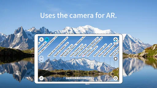
Imagine arriving at a viewpoint during a weekend walk. I can orient the phone toward the horizon, scan the panorama, and use the labels to connect visible peaks with their names. Instead of taking a photograph and hoping to identify the mountains later, I can satisfy that curiosity on the spot, then return to the walk. For a family outing, it can also give children a simple reason to look beyond the path and notice the shape of the surrounding terrain.
One practical habit I’d recommend is checking the view from a stable position before moving on. A few steps or a change in direction can alter what lines up on screen, so pausing helps me compare the displayed panorama with the real skyline. I’d also use the information as a prompt for curiosity, not as proof that I’m standing at a particular location or that a route is safe. Identifying a peak and navigating to it are different jobs.
Offline use and the limits of a visual guide
Offline operation is especially useful where mobile reception fades, but it doesn’t remove every source of uncertainty. A phone still needs a clear view of the landscape for the visual result to be useful. Trees, low cloud, haze, or a crowded foreground can make it harder to match the screen to the horizon. When the display seems doubtful, I’d step to a clearer viewpoint or treat the labels as a best-effort guide rather than insist on a match.
That distinction matters because an offline mountain-identification tool is not the same as an offline topographic map. I wouldn’t rely on it alone for route choices, terrain hazards, or emergency planning. For those tasks, a dedicated navigation solution and sensible preparation are more appropriate. PeakFinder earns its place beside those tools by answering a different question: what are the peaks I can see?
Worth Reading Before You Choose

EA SPORTS FC Mobile 26 Is a Bigger Football Game, but It Takes Time

Flipboard Shows What News Apps Must Do Beyond the Feed

Switching to Android Auto Means Rethinking Your Driving Routine

Google Calendar Makes a Crowded Week Easier to Manage

Ludo King Makes the Most of the Minutes Between Plans

Baby Panda World Brings Quick Play to Modern Phones, but Its Game Library Feels Busy
The app has been available since March 17, 2011, and its current version is 4.8.74. It has a 4.3 average from around 14,000 ratings, with over 500,000 installs. Those figures suggest a well-established niche, though they don’t tell me whether it will suit a particular phone or every landscape. The listed minimum operating-system requirement is version 7.0, so I’d check compatibility before purchasing on an older device.
Where it fits among travel and outdoor apps
Compared with a general map app, this is a narrower, more immediate experience: maps are better for roads, trails, and route context, while a panorama-focused tool is better when I’m already looking at a range and want to name what’s in front of me. A web search can answer the same question when I have a signal and know what to search for, but that is less convenient when I’m outdoors and don’t yet know the name of the peak. Neither alternative makes the other unnecessary.
For photographers, the labels can help with captions and with remembering which ridge appeared in a shot. I’d still record the viewpoint or save a note separately if the exact location matters later. The app can help identify a mountain, but a visual label alone doesn’t preserve the context of a photo shoot or replace a careful field note.
For artists and landscape writers, the benefit is more about observation than logistics. Naming a distant summit can make a scene feel more specific and give a sketch or journal entry a useful anchor. On the other hand, anyone who prefers an unmediated walk may find checking a screen distracting. I’d use it at a viewpoint, then put the phone away rather than keep scanning every few minutes.
Who is likely to get the most from it?
I think it suits hikers who enjoy learning about the places they pass, travelers visiting mountain regions, and people who often stop at overlooks. It’s also a good fit for anyone who likes turning a view into a small geography lesson without carrying a reference book. The strongest case is for someone who expects to use the app across multiple outings, including places with patchy reception.
I’d skip it if I rarely encounter mountain scenery, want a full route planner, or need dependable guidance for backcountry navigation. It may also frustrate someone who expects perfect identification through trees or poor visibility. In those situations, a conventional map, a local trail resource, or simply waiting for a clearer view is the better choice. The app’s focus is its strength, but that focus sets real boundaries.
One useful way to get more out of it is to compare the labeled panorama with a paper or digital map before a hike, not while making a safety-critical decision. That helps me build a mental picture of the surrounding ridges and check whether I’m interpreting the landscape sensibly. For a group, I’d let one person handle the screen while everyone else looks at the skyline; it keeps the tool from becoming the whole outing.
Getting Started with PeakFinder
First things first, downloading and setting up the app is a breeze. Available on both Android and iOS, it’s just a few taps away from being installed on your device. Once you have it, you’re welcomed with a clean, intuitive interface that doesn’t overwhelm you with too many options. It’s designed with simplicity in mind, making it easy for anyone to use.
Features That Stand Out
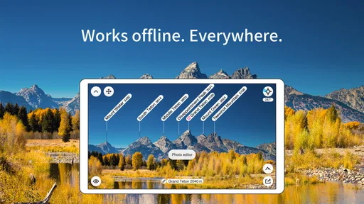
One of the coolest features I discovered is the offline functionality. You can download maps and use the app without an internet connection, which is perfect for those remote hiking locations where reception is spotty at best. Just imagine standing at the top of a mountain, phone in hand, identifying peaks without worrying about losing signal.
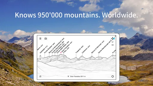
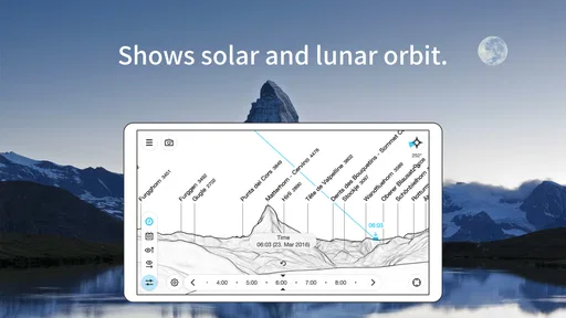
Another standout feature is the 360-degree panoramic display. It’s like a virtual window to the mountains, overlaying peak names on your camera view. This augmented reality feature is so engaging, you might find yourself spinning around just to catch every name! Plus, the app covers a whopping 850,000 peaks worldwide, so it’s unlikely you’ll come across a mountain it doesn’t recognize.
Design and User Experience
The design is sleek and minimalistic. The color scheme is easy on the eyes, and the navigation is straightforward. Whether you’re a tech-savvy millennial or someone just dipping their toes into the app world, you’ll find it user-friendly. I particularly love the night mode feature, which makes it easier to identify peaks during sunrise or sunset hikes.
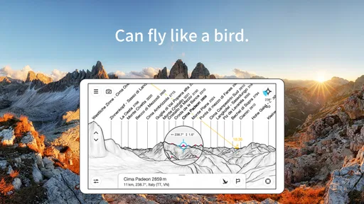
Moreover, the app provides detailed information about each peak. You can learn about elevation, distance, and even the mountain range it belongs to. It’s like having a mini encyclopedia at your fingertips, which is fantastic for those who love to geek out on geographical data.
Practical Uses
While it’s a fantastic tool for hikers and adventurers, PeakFinder is also great for photographers and artists seeking inspiration from the natural world. Knowing the names of the peaks can add a personal touch to your work, be it in writing, painting, or photography.
Even if you’re just a casual explorer, the app enriches your outdoor experience. It encourages you to pause, look around, and connect with your surroundings in a meaningful way. There’s something incredibly satisfying about putting a name to a distant peak and adding it to your list of explored terrains.
Points to Consider
Now, it wouldn’t be a fair review without mentioning a couple of things to keep in mind. While the app is generally smooth, I’ve noticed that in areas with very dense forests or when the weather is overcast, the peak identification can be a bit hit or miss. It’s not a dealbreaker, but something to be aware of.
Also, the app comes with a price tag. While not overly expensive, it might give pause to those who prefer free apps. However, considering the wealth of features and the potential it unlocks, I’d say it’s worth every penny for anyone with a penchant for the outdoors.
Final Thoughts
In conclusion, PeakFinder is a delightful blend of technology and nature. It’s a tool that enhances your outdoor adventures, making them more informative and engaging. Whether you’re a seasoned hiker or someone just starting to explore the beauty of mountain landscapes, this app is a fantastic companion.
So next time you’re out exploring, give PeakFinder a try. It might just change the way you see and appreciate the world around you. Happy hiking!
Pros
- Stunning 360° panoramic views.
- Offline functionality available.
- Accurate peak recognition.
- User-friendly interface.
- Frequent updates enhance features.
Cons
- Limited free version features.
- Battery consumption is high.
- No social media integration.
- Occasional GPS inaccuracies.
- Requires manual calibration.
FAQs for PeakFinder
What is PeakFinder and how does it work?
PeakFinder is an app designed to help users identify mountains and peaks in their vicinity. It uses augmented reality to overlay names on peaks when you point your device's camera at them. The app requires minimal data usage as it operates offline, using a database of over 850,000 peaks worldwide.
Is PeakFinder available for both Android and iOS devices?
Yes, PeakFinder is available for both Android and iOS platforms. Users can download the app from Google Play Store for Android devices and the Apple App Store for iOS devices. It's designed to offer a seamless experience across both platforms with similar features and functionality.
Does PeakFinder require an internet connection to function?
No, PeakFinder does not require an ongoing internet connection to function. It operates offline by downloading all necessary data upon installation. This makes it highly convenient for use in remote areas without cellular service. However, an internet connection is needed for initial data download and updates.
How accurate is PeakFinder in identifying peaks?
PeakFinder is highly accurate due to its extensive database of over 850,000 peaks. It uses GPS data to determine your location and aligns this with its database to provide precise peak names. However, accuracy can be influenced by the GPS signal quality and device sensors.
Are there any additional features available in PeakFinder?
Yes, PeakFinder offers several additional features such as a digital telescope for viewing distant peaks, sunrise and sunset times, and a 3D compass. These features enhance the overall experience, making it not only an educational tool but also a valuable companion for outdoor enthusiasts.


